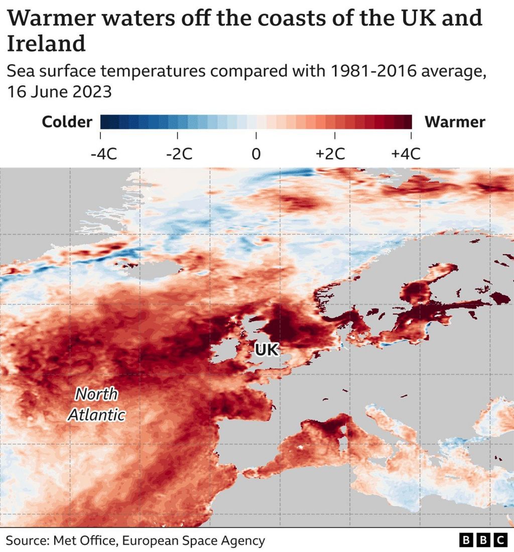
The seas surrounding the UK and Ireland have experienced some of the most extreme marine heat increases on Earth, according to the European Space Agency (Esa).
Esa and the Met Office analysis shows that in some places, water temperatures are up to 3 to 4C from seasonal averages.
From Durham to Aberdeen on the east coast of the United Kingdom and off the coast of northwest Ireland, the sea is especially warm.
Climate change, according to the Met Office, is a contributing factor.
However, it appears that additional, less well-known natural and man-made factors are raising temperatures even more.
According to Esa data, sea temperatures are higher than usual along almost the entire British Isles coastline.
Scientists caution that extreme heat like this can cause fish and other marine life to die, sometimes in large numbers.
Due to storm systems' increased ability to absorb energy and intensify into longer-lasting and more intense storm systems, marine heatwaves—prolonged periods of unusually high sea surface temperatures—are also linked to more severe weather.
The warm seas surrounding the UK coincide with a recent sharp rise in air and ocean surface temperatures worldwide.
In Met Office data going all the way back to 1850, both April and May saw the highest global sea surface temperatures ever.
According to data from the US National Ocean and Atmospheric Administration (NOAA), the average ocean temperature in May was 0°85°C higher than average for the month.
We have witnessed a number of extreme heat events around the globe, with unusually high temperatures contributing to the record-breaking Canadian wildfires that covered New York City in smoke.
Additionally impacted is Asia, where China and some regions of Siberia saw monthly records broken.

The extent of sea ice in the Antarctic is also significantly below average for this time of year.
The array of global temperature records does not indicate that the Earth has passed some sort of climate tipping point, according to Professor Albert Klein Tank, director of the Met Office's Hadley climate research center.
All of these components, he claims, are a result of the climate system's normal variation and are working together to raise sea surface temperatures.
This month has been no exception to the unusually high temperatures.
The EU's Copernicus climate and weather monitoring service reported last week that the first 11 days of June were the hottest ever observed globally for this time of year.
According to the report, this is the first time that during the month of June, global air temperatures have risen by more than 1.5°C above pre-industrial levels.
According to the scientific community, limiting long-term global temperatures to below that 1°C threshold is crucial for preventing the worst effects of climate change.
The 1°C threshold refers to average temperatures over a 20 or 30-year period, so it is anticipated that the current high temperatures will only last temporarily.

However, because of the continued warming of the Pacific Ocean due to the emergence of an El Nio event, experts anticipate more temperature records to be broken in the upcoming months.
2024 is already expected to be the hottest year on record, according to scientists.
The strongest climate change that has ever occurred on Earth is known as El Nio.
When warm waters rise to the surface off the coast of South America and spread across the ocean, generating significant heat in the atmosphere, the El Nio Southern Oscillation, or ENSO, as it is known scientifically, is entering its hot phase.
The North Atlantic, however, is currently experiencing the most pronounced rise in sea surface temperature. .
The Met Office reports that temperatures in May were 1 degree 25 degrees Celsius above the long-term average, the highest monthly deviation ever.
Although scientists are unsure of the exact cause of the record-breaking heat in the waters off the UK and in the North Atlantic, they do agree that climate change is unquestionably a major factor. Global temperatures are rising as a result of the continued release of massive amounts of planet-warming carbon dioxide into the atmosphere.
But it's likely that other elements are also at play.
Weaker than average winds, according to Professor Michael Mann of Penn State University's Department of Atmospheric Science, have decreased the amount of Saharan dust in the atmosphere.
Sea surface temperatures are moderated by saharan dust, which absorbs and reflects some of the sun's energy.
A persistent weather pattern with easterly winds from the US mainland may also have contributed to warming the sea surface this year, which has seen unusually light trade winds.

The results of lessened shipping-related pollution may also play a role.
The International Maritime Organization (IMO) implemented regulations in 2020 to lower the amount of sulfur in ship fuel.
The IMO claims that this substantially lowers the quantity of aerosol particles released into the atmosphere.
A greater amount of heat may have entered the waters as a result of the aerosols' removal because they contribute to air pollution and can help reflect heat back into space.
It appears that the effects of the North Atlantic's unusually warm temperatures are already starting to be felt.
According to the Met Office, an Atlantic tropical storm is likely to form east of the Caribbean by the middle of this week. The eastern tropical Atlantic is the primary spawning ground for North Atlantic hurricanes.
It is extremely unusual, according to Julian Heming of the Met Office, to see a storm forming there so early in the season.
The Met Office predicts that this year's season of tropical storms and cyclones in the North Atlantic basin will be above average due to the high surface temperatures. Normally, hurricane development is suppressed during El Nio periods.
According to the Met Office, the hot weather is expected to last.
It states that there is a 45% chance—significantly higher than usual—that the UK will experience what it refers to as a "hot summer."